News
December 2024
Two Russian oil tankers, the Volgoneft-212 and the Volgoneft-239, suffered damages in the Kerch Strait during a storm, with one sinking and the other running aground. The ships were carrying 9,200 tonnes of heavy fuel oil, about 40% of which may have spilled into the sea, according to Russian authorities. The transport and fate of spilled oil have been operationally predicted by the CMCC team with MEDSLIK-II using satellite-derived imagery. Find the details via the link: https://www.cmcc.it/article/oil-spill-accurate-forecasts-from-cmcc-on-the-kerch-strait
November 2024
A presentation entitled “WITOIL on cloud. Usage of MEDSLIK-II in the DIGITAL TWIN environments“ was successfully delivered by Igor Ruiz Atake (CMCC) at the MonGOOS Workshop 2024 “Boost the understanding of the Mediterranean for adaptation to climate change and extreme events“ held at the Spanish Institute of Oceanography, Malaga, Spain on 2-3 October 2024. In the discussion afterward, the MEDSLIK-II Consortium members and users overviewed current problems and gaps in the code highly demanded in the ocean-science society. The CMCC, ORION, FORTH, and DUTH representatives participated in the discussion.
June 2020
The new release MEDSLIK-II v2.01 was presented at the MEDSLIK-II Steering Committee decision oriented online meeting 17-19 June 2020 (Virtual Host: CMCC). In comparison with the MEDSLIK- II v2.0, MEDSLIK- II v2.01 version includes bug fixes. The Python scripts are ported from Python 2 to Python 3. Additionally, a configuration file conf.json is implemented.
December 2019
The new global version MEDSLIK-II v2 is presented at the 8th MONGOOS ANNUAL MEETING, Trieste (Italy) 3-5 December 2019 Presentation abstract: A new release of the MEDSLIK-II-v2 oil spill model has been presented in comparison with the previous versions. The new features provide a possibility to apply MEDSLIK-II-v2 for any region of the global using the CMEMS and ERA-Interim datasets and to deliver rawer outputs than in the previous versions.
The model performance has been illustrated by the Sanchi oil spill happened in the East China Sea, January 2018.
October 2019
After the recent success of the European Geosciences Union Session on marine pollution, we are pleased to announce that we will convening again the updated session at the EGU Annual Meeting, in Vienna from 3-8 May 2020.
The session, OS4.9: Marine Pollution Monitoring, Predictions and Risk Mapping deals with all the types of marine pollution, from oil spills to radioactive material (see abstract below). Please consider submitting your abstract for our session.
== OS4.9: Oceanographic monitoring and modeling are both widely used to study the pathways and fate of marine pollutants such as hydrocarbons, marine litter, POPs, HNS, radionuclides, etc. In this session, advanced sampling methods, models, operational applications and techniques related to tracing pollutants on local, regional and global scales, as well as the coupling with met-oceanographic transport fields from operational oceanography products such as Copernicus Marine Monitoring Environment Service will be discussed. State-of-the-art observational techniques and protocols, ensemble and multi-model methods, risk assessment algorithms and decision support systems are solicited topics. Integration of modelling and observing systems for both data assimilation and model validation are also very welcome. Key questions of the session are identified as follows: Which factors affect the dispersion of the pollutants in the marine environment? What happens to the contaminants on the ocean's surface, in the water column and sediments? How do marine pollutants interact with marine habitats? How do they influence marine and maritime resources? How should Integrated Coastal Zone Management (ICZM) protocols be optimized to minimize negative impact on the coastal zone? Impacts of pollutants, including light and noise pollution, on the marine ecosystems and resilience to pollution events are also important subjects for discussion: What is the behavior of oil, marine litter, heavy metals, and other pollutants in the water column, on various beach sediments, rocks and seabed? e.g., what is the biodegradation rate of oil droplets in the water column and what are the controlling factors? What is the rate of fragmentation, biofouling, and sedimentation of plastics? What are the mechanisms of beaching, seabed deposition, and resuspension of marine pollutants and what are the ways of entering the marine food chains (including human consumption)? What is the impact of light and noise pollution on the marine environment and habitats?
December 2016
After the success of last year first edition of the European Geosciences Union session on marine pollution, we are pleased to announce that we will convening again the session at the EGU Annual Meeting, in Vienna from 23-28 April 2017.
The session, OS4.7: Marine Pollution Assessment, Predictions and Risk Mapping deals with all types of marine pollution, from oil spills to radioactive material (see abstract below). Please consider submitting an abstract for our session. Let me know if you have any questions and find below the instructions for submission. Look forward to hopefully seeing you in Vienna in April!
== OS4.7: Marine Pollution Assessment, Predictions and Risk Mapping Convener: Giovanni Coppini Co-Conveners: George Zodiatis , Ramiro Neves , Erik van Sebille Oceanographic modelling is widely used to study the pathways and fate of marine pollutants such as oil spills, plastic litter, radionuclides and other contaminants. In this session, advanced models, operational applications and techniques related to polluting tracers on local, regional and global scales will be discussed, as well as the coupling with met-oceanographic transport fields from operational oceanography products such as Copernicus Marine Monitoring Environment Service. Parcel trajectory numerical schemes, ensemble and multi-model methods, uncertainties estimation, risk algorithms and decision support systems are solicited topics. Impacts of pollutants on the marine ecosystem and resilience to pollution events are also important subjects for discussion. Integration of modelling and observing systems both for data assimilation and validation are also very welcome.
November 2013
Two papers on MEDSLIK-II available!
The MEDSLIK-II model description and validations have been published in two papers on the Geoscientific Model Development journal.
The first paper describes the MEDSLIK-II numerical model equations and the conceptual assumptions of a Lagrangian marine surface oil slick numerical model.
It is available for download at the following link: M. De Dominicis, N. Pinardi, G. Zodiatis, and R. Lardner (2013): MEDSLIK-II, a Lagrangian marine surface oil spill model for short-term forecasting - Part 1: Theory In the second paper, MEDSLIK-II has been used to simulate oil slick transport and transformation processes for realistic oceanic cases, where satellite or drifting buoys data are available for verification.
It is available for download at the following link: M. De Dominicis, N. Pinardi, G. Zodiatis, and R. Archetti (2013): MEDSLIK-II, a Lagrangian marine surface oil spill model for short-term forecasting - Part 2: Numerical simulations and validations
February 2013
A plenary session on MEDSLIK-II will take place on 6th of February from 15:20 to 17:00 at the Castello Carlo V, Lecce, Italy, as a side event of the
The first MEDSLIK-II Steering Committee annual meeting will be held on the 7th of February 14:00-18:00 at CMCC premises in Lecce, Italy.
October 2012
MEDSLIK-II will be launched as a community model, freely available to the users the 22nd of October 2012, at the INGV (Istituto Nazionale di Geofisica e Vulcanologia) in Bologna (Italy). The MEDSLIK-II code will be freely available with the aim of attracting a critical mass of scientists to contribute to the development of the code and to use the model in very different conditions.
The MEDSLIK-II official release meeting will be the 22nd of October 2012 in Bologna (Italy).
Please find the Agenda and some practical information to reach us (Hotel info and How to Reach us).
March 2012
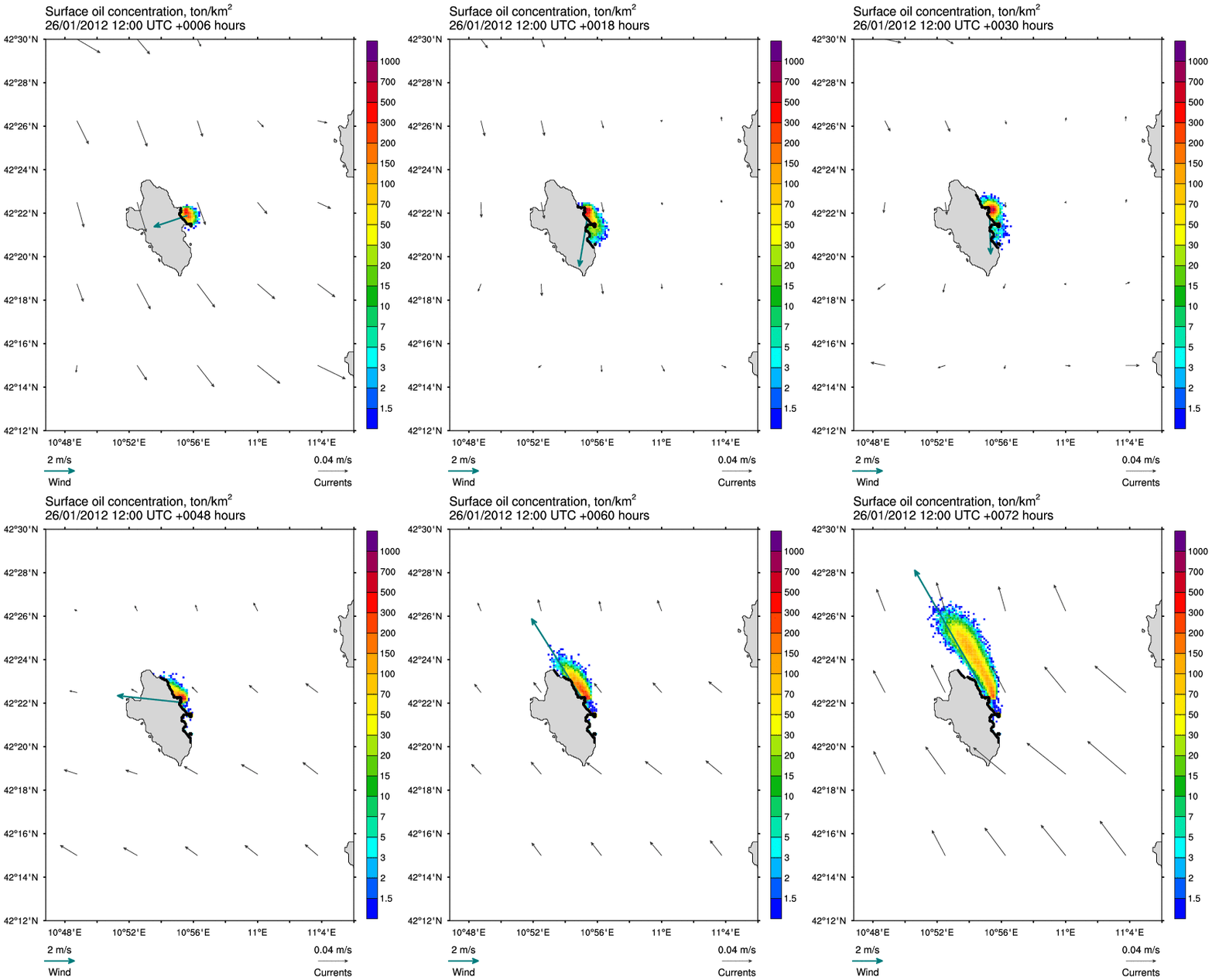
MyOcean forecasting products in the Mediterranean Sea produced by MyOcean's member INGV (Istituto Nazionale di Geofisica e Vulcanologia) have been coupled with the oil spill model MEDSLIK-II, for simulating the propagation of the oil into the sea. The oil spill forecasting system based on MyOcean products and MEDSLIK-II has been run by INGV who produced daily oil spill bulletin. MEDSLIK-II has been used to forecast the possible spill of the 2500 tons of oil from the Costa Concordia, assuming a continuous oil release. Every day, until the unloading operations had run out, a bulletin with the forecast scenario for the next 72 hours has been released to the competent authorities. Moreover the oil spill forecasting system was already installed at Italian Coast Guard premises' so that they produce themselves daily the oil spill bulletin.

February 2012
MEDSLIK-II will be one of the oil spill models used in the MEDESS-4MS project.
MEDESS-4MS project has started the 1st of February 2012 and will deliver an integrated operational multi model oil spill prediction service in the Mediterranean Sea.

